6.Trail route signing#
6.1Scope#
This section sets out the general principles for installation and location of trail signs for National and local trail routes.
6.2General#
The National Trail is a trail provided for bushwalkers and horse riders. It extends from Cooktown in Queensland to Melbourne, Victoria. The trail includes historic sites and, where possible, follows the route travelled by pioneers. The Trail has been designed to ensure minimal conflict between motorists and trail users.
Local Trail routes have also been implemented in Queensland and, largely, follow the same intent of National Trails; however, these local routes may have different signing arrangements.
6.3Trail signs#
A number of signs have been developed for use in conjunction with trail routes. These signs fall into two categories:
- a) signs on the road to warn motorists of possible conflicts with trail users
- b) signs on the trail to warn trail users of the presence of a road and to direct trail users.
Signing of these crossings may be omitted where all of the following apply:
- 1.traffic volumes are less than 500 vehicles per day, and
- 2.there is sufficient sight distance, from vehicles to the trail users at the crossing point and vice versa, as per the Road Planning and Design Manual Volume 3 Part 3, and
- 3.sight distance is maintained: that is, through regular roadside maintenance.
6.3.1Signs on the road#
6.3.1.1Trail crossings#
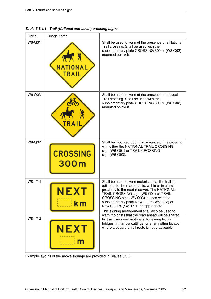
Trails may be either Local or National Trails, with different signing schemes existing for each. Signs may be used as per Table 6.3.1.1 following.
| Signs | Usage notes | |
|---|---|---|
| W6-Q01 | Shall be used to warn of the presence of a National Trail crossing. Shall be used with the supplementary plate CROSSING 300 m (W8-Q02) mounted below it. | |
| W6-Q03 | Shall be used to warn of the presence of a Local Trail crossing. Shall be used with the supplementary plate CROSSING 300 m (W8-Q02) mounted below it. | |
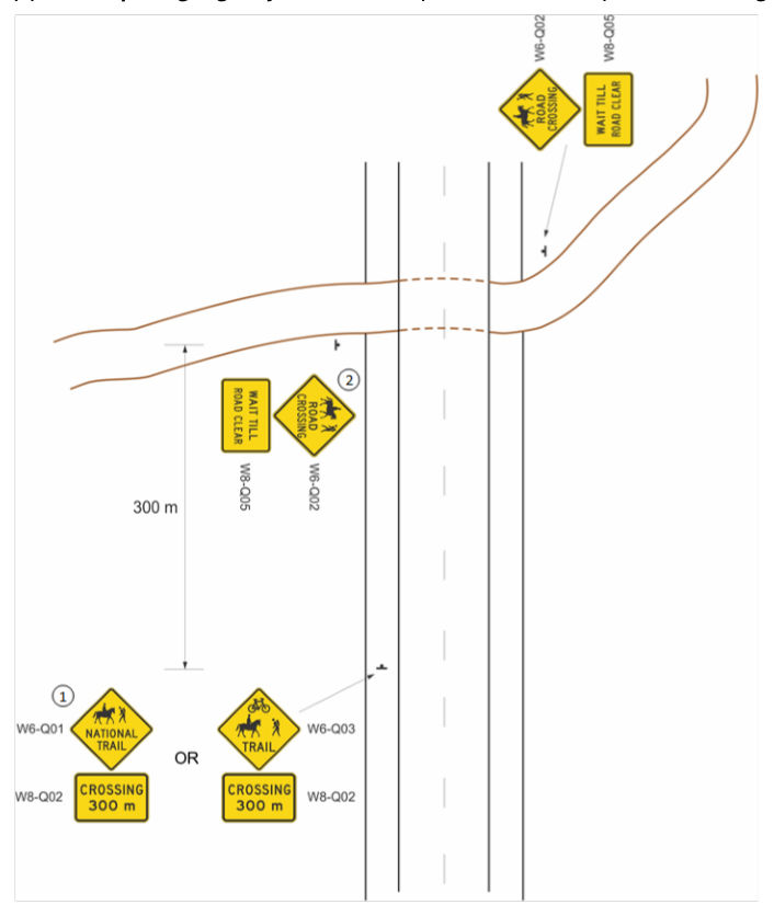
| W8-Q02 | Shall be mounted 300 m in advance of the crossing with either the NATIONAL TRAIL CROSSING sign (W6-Q01) or TRAIL CROSSING sign (W6-Q03). | |
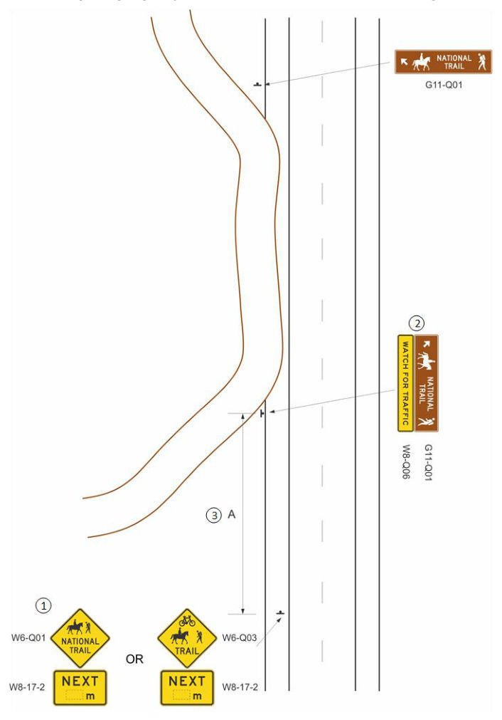
| W8-17-1 | Shall be used to warn motorists that the trail is adjacent to the road (that is, within or in close proximity to the road reserve). The NATIONAL TRAIL CROSSING sign (W6-Q01) or TRAIL CROSSING sign (W6-Q03) is used with the supplementary plate NEXT ... m (W8-17-2) or NEXT … km (W8-17-1) as appropriate. This signing arrangement shall also be used to warn motorists that the road ahead will be shared by trail users and motorists: for example, on bridges, in narrow cuttings, or at any other location where a separate trail route is not practicable. | |
| W8-17-2 |
Example layouts of the above signage are provided in Clause 6.3.3.
6.3.2Signs on the trail#
6.3.2.1Trail road crossing#
The National trail ROAD CROSSING sign (W6-Q02) is used immediately preceding a road crossing of a trail with the supplementary plate WAIT TILL ROAD CLEAR (W8-Q05) mounted below it.
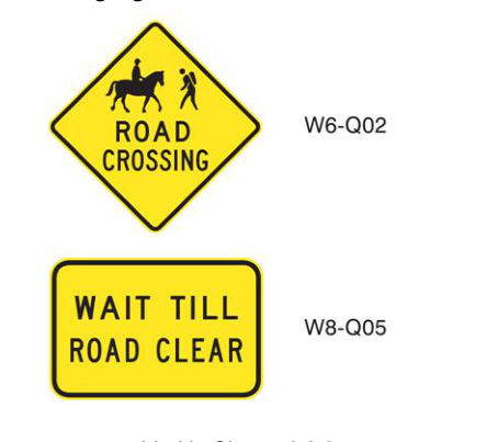
Example layouts of this signage are provided in Clause 6.3.3.
6.3.2.2National trail direction signs#
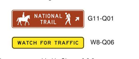
The NATIONAL TRAIL direction sign (G11-Q01) should be used on the National Trail where it is on or adjacent to a road, to direct the trail user. The WATCH FOR TRAFFIC (W8-Q06) should be used with the initial G11-Q01 and any repeater signs, to warn of possible conflicts with motorists.
Example layouts of this signage are provided in Clause 6.3.3.
6.3.3Example signage layouts#
Example signage layouts for trail routes (National or Local) are provided in the following figures.